Exploring Geography
Middle and South America

-rankopedia.com
Number of Countries within Region: 29
Argentina, Bahamas, Barbados, Belize, Bolivia, Brazil, Chile, Columbia, Costa Rica, Cuba, Dominican Republic, Ecuador, El Salvador, Guatemala, Guyana, Haiti, Honduras, Jamaica, Mexico, Nicaragua, Panama, Paraguay, Peru, Puerto Rico, Suriname, Tobago, Trinidad, Uruguay and Venezuela.
Physical Features
Amazon River “Rio Amazonas”
The Amazon begins 100 miles off the Pacific Ocean in the Peruvian Andes Mountains and flows through Northern Brazil. The Amazon flows east while traveling 4,000 miles through South America and pouring into the Atlantic. The Amazon is considered the largest river in the world when measuring the amount of water within it and by how much drainage it is responsible for. The only river larger in size is the Nile River.
The Amazon begins 100 miles off the Pacific Ocean in the Peruvian Andes Mountains and flows through Northern Brazil. The Amazon flows east while traveling 4,000 miles through South America and pouring into the Atlantic. The Amazon is considered the largest river in the world when measuring the amount of water within it and by how much drainage it is responsible for. The only river larger in size is the Nile River.

-commons.wikimedia.org
The Andes Mountains
The Andes Mountains reside on the western side of South America running from north to south. They have tectonic activity, because of this, earthquakes are not uncommon. The Andes are very large in size and are higher in elevation than the Rocky Mountains; however, the mountain range does not cover as much space.
The Andes Mountains reside on the western side of South America running from north to south. They have tectonic activity, because of this, earthquakes are not uncommon. The Andes are very large in size and are higher in elevation than the Rocky Mountains; however, the mountain range does not cover as much space.
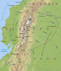
-ecuadoradventure.ec
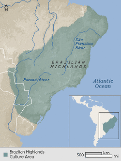
Brazilian Highlands/Guiana Highlands
The Brazilian Highlands, considered a low Mountainous or plateau sub-region run north to the southwest of South America. They make up almost half of South America’s land mass, and hold many of the resources. The Highlands are north of the Amazon, yet south of the Orinoco River. They cover the southern half of Venezuela, the Guiana's, the northern portion of Brazil and a small portion of southeastern Columbia.
The Brazilian Highlands, considered a low Mountainous or plateau sub-region run north to the southwest of South America. They make up almost half of South America’s land mass, and hold many of the resources. The Highlands are north of the Amazon, yet south of the Orinoco River. They cover the southern half of Venezuela, the Guiana's, the northern portion of Brazil and a small portion of southeastern Columbia.
-eslb2isbhumanities.wikispaces.com
Cape Horn
Along the coast of the southern tip of South America, the Cape Horn sits in the drake passage of the Pacific Ocean between South America and Antarctica.
Cape Horn is one of the most challenging, sought after sailing routes in the world.
Along the coast of the southern tip of South America, the Cape Horn sits in the drake passage of the Pacific Ocean between South America and Antarctica.
Cape Horn is one of the most challenging, sought after sailing routes in the world.


Panama Canal
The Panama Canal is a shipping canal located in the coast of Central America. It lies between the Atlantic and Pacific Oceans running east to west.
The canal saves nearly 8,000 miles of travel around South America by being able to travel through the Central Canal.
The Panama Canal is a shipping canal located in the coast of Central America. It lies between the Atlantic and Pacific Oceans running east to west.
The canal saves nearly 8,000 miles of travel around South America by being able to travel through the Central Canal.

-geography.howstuffworks.com
Climate
There are very large variations in the climates in Middle and South America. The Amazon experiences a Tropical Wet climate, while the West Coast deals with desert dry conditions. In the high elevations of the Andes Mountains an Arctic cold climate is present. It is thought that the vast differences are due to the large land masses on either side of the equator. Of course this is not the only reason; the Mountains create changes in altitudes that also produce a wide range of temperatures. The Oceans are also responsible for changes in the weather patterns with winds and currents resulting in precipitation patterns. Hurricanes unfortunately are abundant in this region.
There are four main temperature-altitude zones in this region.
Tierra Caliente ("hot land")
As altitudes increase temperatures drop, making the lowlands experiences the warmest temperatures in this region. This zone exists up to 3000 feet in elevation and covers a very large portion of Middle and South America. Moisture and warm temperatures support the tropical rain forests and tropical crops (Bananas, sugarcanes, pineapples, etc.)
Tierra Templada ("temperate lands")
This zone is between 3000 and 6500 feet of elevation. It is cooler than the Tierra Caliente, temperature, described as a year-round spring climate. This climate was very desirable among the indigenous people and European's for the climate and soil conditions. Many crops strived in these areas including: corn, beans, squash, green vegetables, wheat and coffee.
Tierra Fria ("cool lands")
This zone resides between 6500 and 12,000 feet in elevation. Tierra Fria is home to many midlatitude crops, such as: fruits trees, root vegetables (potatoes, onions and carrots), cabbage and broccoli. There are 3 major cities in this climate range; Mexico City, Equador and Quito
Tierra Helada ("frozen helada")
In some lower areas of this climate zone a few crops can be planted. These include some grains and root vegetables. To substitute fiber; llamas, sheep and guinea pigs are raised and added to the diet because in higher altitudes the cultivation of crops is nonexistent.
This zone resides above 12,000 feet in elevation.
Resources
The Brazilian Highlands are home to many of the regions resources. There you will find titanium, iron ore and manganese. While Middle/Central America relies on tourism, South America relies on mining, fishing, forestry and agriculture for their economy.
Environmental Issues
Central America:
In Central America, farming fertilizer and pesticides are a big cause for concern. There is massive run off from mountains and highlands into waterways. The use of the fertilizers and pesticides is needed because there is not enough land to support the growth demand naturally. The threat is very dangerous. Many children are suffering from allergies and poisonings. In some cases, children die from their ailments caused by the pollution.
In Central America, farming fertilizer and pesticides are a big cause for concern. There is massive run off from mountains and highlands into waterways. The use of the fertilizers and pesticides is needed because there is not enough land to support the growth demand naturally. The threat is very dangerous. Many children are suffering from allergies and poisonings. In some cases, children die from their ailments caused by the pollution.
South America:
In South America Logging of Hardwoods is causing great concern for the entire region. The land is needed for farming. After the forest is cleared and the land is used for farming for a few years, it is left in search for new land because the soil has been depleted of minerals.
The wood is generally used to build furniture. It is generally sold to the United States; a single tree could earn up to $300,000.
The logging of the hardwood is a concern for the environment, because it is of the largest forests in the world and is a huge consumer of carbon dioxide.
Pesticides and Fertilizers Deforestation


- ourealife.wordpress.com - greenpeace.org
Population Patterns
The birth rates are still very high in Middle and South America (families are very large.) Many citizens seek employment opportunities out of the country, and migrate to accompany the position. There is nearly twice the amount of people in Middle and South America than in North America. The Majority of the citizens live along the coastlines, in very congested areas.
Role of Gender
Family and community are first priority in Middle and South America. It is not uncommon for extended members of the family to all be living in the same house (grandparents, parents and siblings, and their children.) The relationships among the family members are very close, and they prefer to spend social time outside of the house together too. Siblings, nieces and aunts consider each other best friends. Brothers, uncles and nephews become business partners and work together outside of the home. The family has very strong religious beliefs and traditions that are still held into place in their lives today.
Women are to follow "marianismo", which is set values to follow such as; chastity, motherhood and service to the family.
Men are to follow "machismo" which considers men to consist of honor, respect, and the ability to be a father, financial supporter and the master of the household. Men have much more freedom in their social lives and with members of the same and opposite sex outside of the family.

-everyculture.org
Religion
The primary religion in Middle and South America originally was Roman Catholic, however, power of this religion started to diminish in the 19th century. Today the primary religion is Evangelical Protestantism; this belief structure is migrating south from North America and has become the fastest growing religious belief in Middle and South America.
Transportation
Whether by car, bus or taxi, transportation by road seems to be the most common form of travel throughout most of Middle and South America. In more developed areas the roads are in far better condition than in the areas stricken by poverty. This region has a large amount of tourism, and the taxis and buses accommodate these travelers very well. Generally, this form of travel is inexpensive and safe.
Country of Focus
Brazil
Brazil gained its independence in 1822, following nearly three centuries of being ruled by Portuguese. The country is located on the east central side of South America, and covers nearly half of the continent. It is by far the most populous country in South America (203,429,773 (July 2011 est.)), and is the largest country in South America with a total land and water mass of 8,514,877 sq. km. In comparison, Brazil is just slightly smaller than the United States. Brazil has the largest economy, placing the eighth largest in the world. Most of the minerals found in South America today are found in the Brazilian Highlands, including iron ore, manganese, gold, nickel and titanium. The climate is mostly tropical, but more temperate in the southern portion of the country. Deforestation is heavy in the Amazon Basin and has destroyed the habitat and endangered many plants and animal species.
Brazil gained its independence in 1822, following nearly three centuries of being ruled by Portuguese. The country is located on the east central side of South America, and covers nearly half of the continent. It is by far the most populous country in South America (203,429,773 (July 2011 est.)), and is the largest country in South America with a total land and water mass of 8,514,877 sq. km. In comparison, Brazil is just slightly smaller than the United States. Brazil has the largest economy, placing the eighth largest in the world. Most of the minerals found in South America today are found in the Brazilian Highlands, including iron ore, manganese, gold, nickel and titanium. The climate is mostly tropical, but more temperate in the southern portion of the country. Deforestation is heavy in the Amazon Basin and has destroyed the habitat and endangered many plants and animal species.

- state.gov
Health Care Practices
Basic health care is provided to all citizens. Prenatal care and delivery is covered by the government, and almost all newborns are born in the hospital.
HIV/AIDS is increasing at an alarming rate in Middle and South America. Nearly 1.8 million people are affected and 60,000 of them are children. The explanation on why this is happening is because men in this region are not expected to be monogamous, so women are extremely vulnerable. Safe sex practices are frowned upon, and are against their beliefs. Infants and children become affected during deliver, prior to mother's diagnosis. There is a rising concern, because many cannot afford the medical and pharmaceutical expenses for this disease.
HIV/AIDS is increasing at an alarming rate in Middle and South America. Nearly 1.8 million people are affected and 60,000 of them are children. The explanation on why this is happening is because men in this region are not expected to be monogamous, so women are extremely vulnerable. Safe sex practices are frowned upon, and are against their beliefs. Infants and children become affected during deliver, prior to mother's diagnosis. There is a rising concern, because many cannot afford the medical and pharmaceutical expenses for this disease.
